> ## Documentation Index
> Fetch the complete documentation index at: https://docs.ones1ght.com/llms.txt
> Use this file to discover all available pages before exploring further.
# Mobile Positioning Data Lookup
> Check the positioning coordinates and zone events collected by the mobile SDK in the Positioning Data (Mobile) data source, and query the raw data.
'Positioning Data (Mobile)' is the raw location data collected by the mobile SDK. In Data Sources you can check the collection status and query or download positioning coordinates and zone enter and exit events.
## 1) Opening Data Sources
Access the OneS1ght console at [`console.ones1ght.com`](https://console.ones1ght.com).
The Data Sources menu is visible only to **manager and above**. If you have no account or lack the permission,
ask your organization's owner or manager for an invitation and the permission. OneS1ght is invite-only, so there is no self-signup.
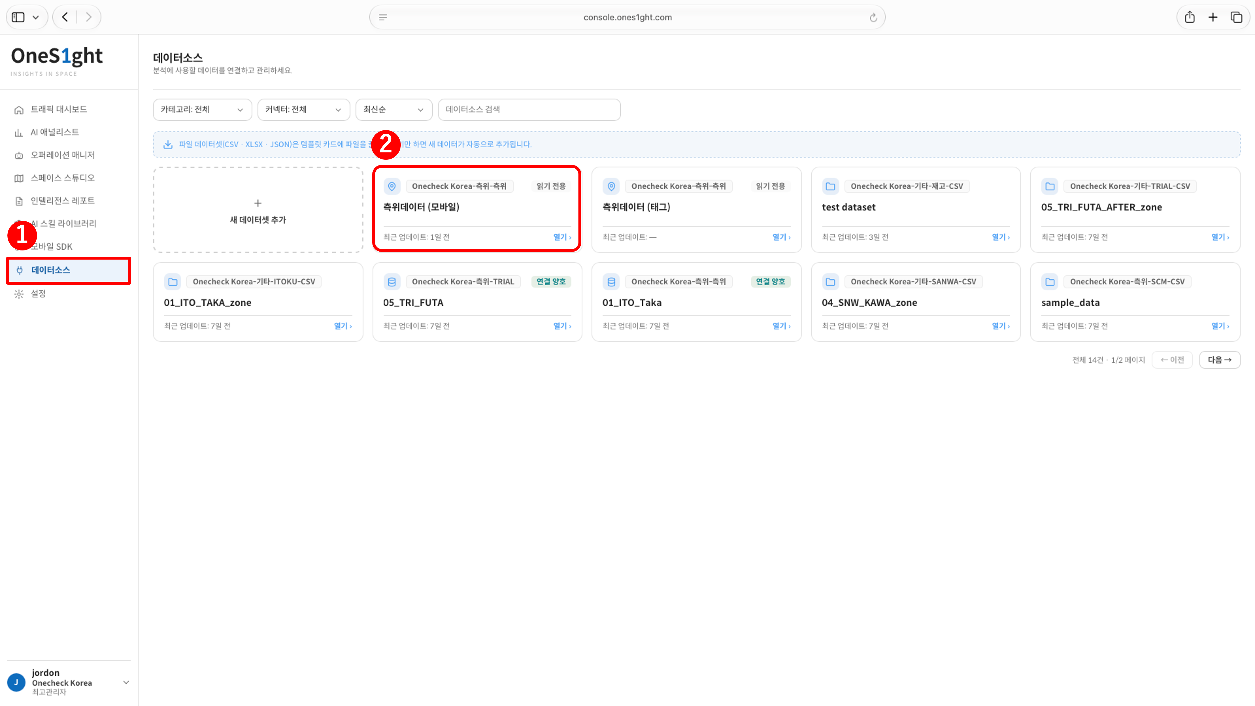 1. Log in to the OneS1ght console, then go to \[Data Sources] in the sidebar.
2. Click \[Open] on the 'Positioning Data (Mobile)' card. This is the raw location data collected by the mobile SDK and is read-only.
## 2) Checking the Data Overview
1. Log in to the OneS1ght console, then go to \[Data Sources] in the sidebar.
2. Click \[Open] on the 'Positioning Data (Mobile)' card. This is the raw location data collected by the mobile SDK and is read-only.
## 2) Checking the Data Overview
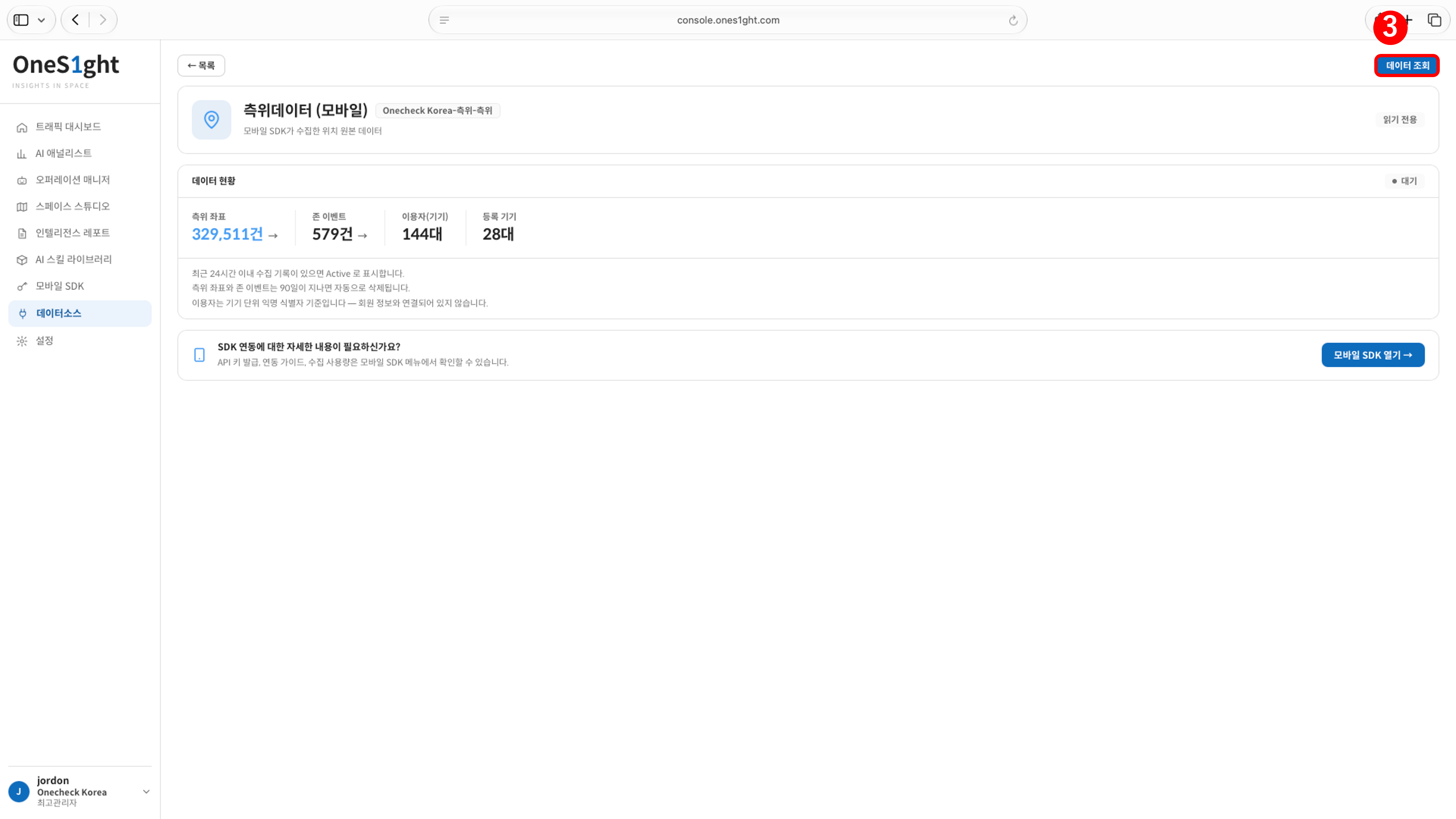 The Data Overview shows the counts collected so far.
| Item | Description |
| - | - |
| Positioning coordinates | ·Number of coordinates collected by the mobile SDK·Click to go to the raw data query screen |
| Zone events | ·Number of zone enter and exit events |
| Users (devices) | ·Number of users based on the anonymous per-device identifier·Not linked to member information |
| Registered devices | ·Number of registered devices |
* The status indicator at the top right of the Data Overview shows **Active** when coordinates were collected within the last 24 hours, and **Waiting** otherwise.
* Positioning coordinates and zone events are deleted automatically after 90 days.
If you open this screen right after running positioning with the verification app, the status should be **Active** and the positioning coordinate count should be higher than before verification.
If the status stays 'Waiting' or the count does not increase, coordinates are not reaching the server;
contact [onesight-support@onecheck.co.kr](mailto:onesight-support@onecheck.co.kr).
## 3) Querying Raw Data
Click \[Query Data] (③) at the top right of the Data Overview screen to open the 'Mobile (SDK) Raw Data' screen.
The Data Overview shows the counts collected so far.
| Item | Description |
| - | - |
| Positioning coordinates | ·Number of coordinates collected by the mobile SDK·Click to go to the raw data query screen |
| Zone events | ·Number of zone enter and exit events |
| Users (devices) | ·Number of users based on the anonymous per-device identifier·Not linked to member information |
| Registered devices | ·Number of registered devices |
* The status indicator at the top right of the Data Overview shows **Active** when coordinates were collected within the last 24 hours, and **Waiting** otherwise.
* Positioning coordinates and zone events are deleted automatically after 90 days.
If you open this screen right after running positioning with the verification app, the status should be **Active** and the positioning coordinate count should be higher than before verification.
If the status stays 'Waiting' or the count does not increase, coordinates are not reaching the server;
contact [onesight-support@onecheck.co.kr](mailto:onesight-support@onecheck.co.kr).
## 3) Querying Raw Data
Click \[Query Data] (③) at the top right of the Data Overview screen to open the 'Mobile (SDK) Raw Data' screen.
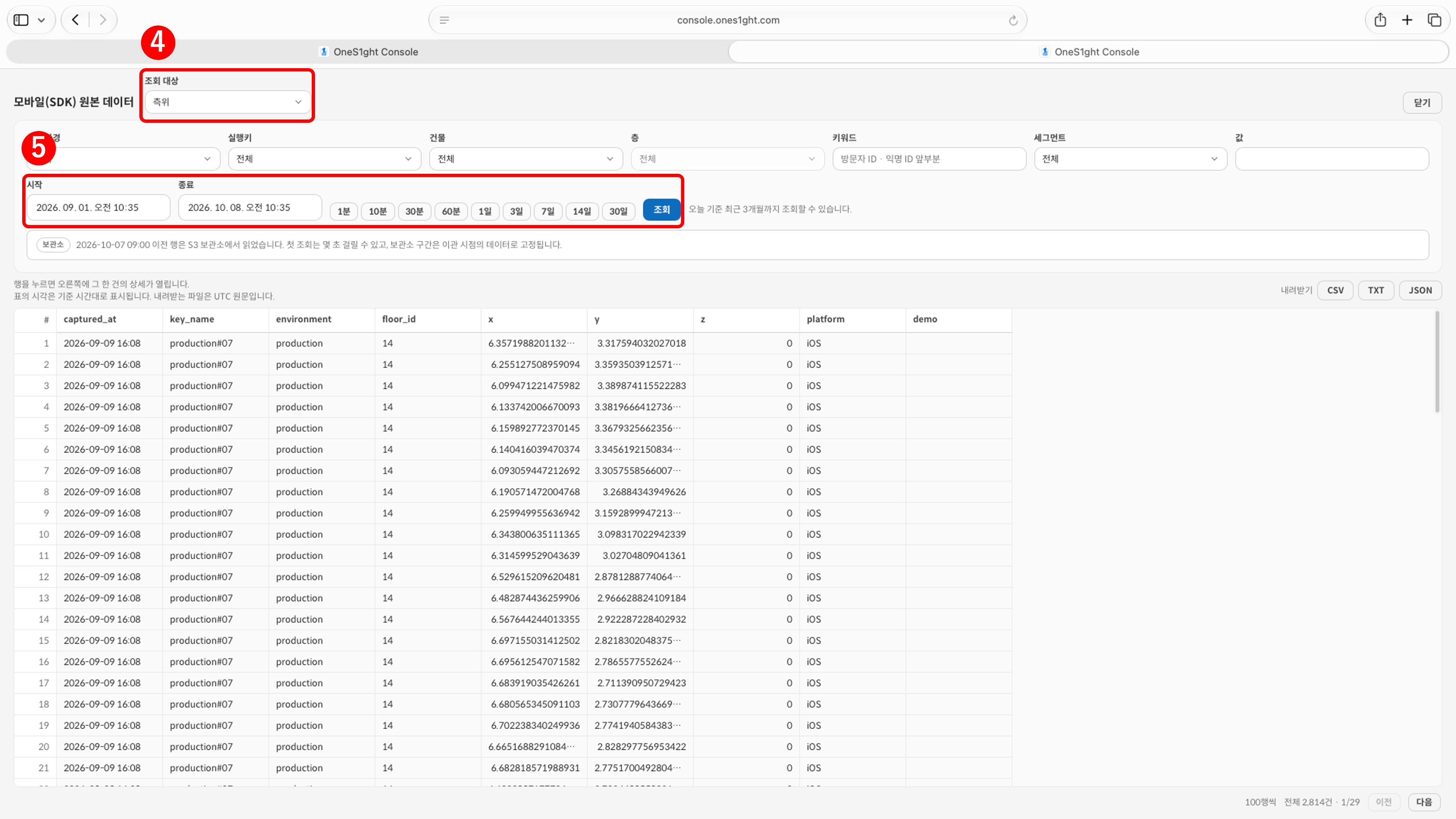 1. Select the query target. 'Positioning' is the collected coordinates; 'Events' is the zone enter and exit records.
2. Set the start and end time or click a period button (1 minute to 30 days), then click \[Query]. You can query up to the last 3 months from today.
3. If needed, narrow the results by building, floor, environment, SDK key, or keyword (the beginning of a visitor ID or anonymous ID). For 'Events' you can also narrow by zone.
**When the query target is 'Positioning'**
| Column | Description |
| - | - |
| captured\_at | ·Collection time. Shown in the table in the reference time zone; the downloaded file keeps the original UTC value |
| key\_name · environment | ·Name and environment of the SDK key that sent the coordinates |
| floor\_id | ·Floor ID |
| x · y · z | ·Positioning coordinates (m): the width and depth distance from the reference point, and the height |
| platform | ·iOS or Android |
**When the query target is 'Events'**
| Column | Description |
| - | - |
| occurred\_at | ·Time the event occurred |
| key\_name · environment | ·Name and environment of the SDK key that sent the event |
| floor\_id · zone\_id · zone\_name | ·Floor and zone where the event occurred |
| status | ·IN: entered the zone·OUT: exited the zone |
| profile\_id · visitor\_id | ·Anonymous per-device identifier. Not linked to member information |
| platform | ·iOS or Android |
* Click a row to open the details of that record on the right.
* You can download the query results as \[CSV] · \[TXT] · \[JSON].
Ranges marked with an archive notice (rows from before the migration point) are read from the S3 archive, so the first query may take a few seconds.
## Checklist
Check these together with verification after setting up the positioning infrastructure.
| # | Item | Check |
| - | - | :-: |
| 1 | The 'Positioning Data (Mobile)' Data Overview shows the status Active, and the positioning coordinate count has increased after verification. | ☐ |
| 2 | The raw data query returns coordinate rows for the time range in which you verified. | ☐ |
This documentation is built and hosted on [Mintlify](https://mintlify.com), a developer documentation platform.
1. Select the query target. 'Positioning' is the collected coordinates; 'Events' is the zone enter and exit records.
2. Set the start and end time or click a period button (1 minute to 30 days), then click \[Query]. You can query up to the last 3 months from today.
3. If needed, narrow the results by building, floor, environment, SDK key, or keyword (the beginning of a visitor ID or anonymous ID). For 'Events' you can also narrow by zone.
**When the query target is 'Positioning'**
| Column | Description |
| - | - |
| captured\_at | ·Collection time. Shown in the table in the reference time zone; the downloaded file keeps the original UTC value |
| key\_name · environment | ·Name and environment of the SDK key that sent the coordinates |
| floor\_id | ·Floor ID |
| x · y · z | ·Positioning coordinates (m): the width and depth distance from the reference point, and the height |
| platform | ·iOS or Android |
**When the query target is 'Events'**
| Column | Description |
| - | - |
| occurred\_at | ·Time the event occurred |
| key\_name · environment | ·Name and environment of the SDK key that sent the event |
| floor\_id · zone\_id · zone\_name | ·Floor and zone where the event occurred |
| status | ·IN: entered the zone·OUT: exited the zone |
| profile\_id · visitor\_id | ·Anonymous per-device identifier. Not linked to member information |
| platform | ·iOS or Android |
* Click a row to open the details of that record on the right.
* You can download the query results as \[CSV] · \[TXT] · \[JSON].
Ranges marked with an archive notice (rows from before the migration point) are read from the S3 archive, so the first query may take a few seconds.
## Checklist
Check these together with verification after setting up the positioning infrastructure.
| # | Item | Check |
| - | - | :-: |
| 1 | The 'Positioning Data (Mobile)' Data Overview shows the status Active, and the positioning coordinate count has increased after verification. | ☐ |
| 2 | The raw data query returns coordinate rows for the time range in which you verified. | ☐ |
This documentation is built and hosted on [Mintlify](https://mintlify.com), a developer documentation platform.